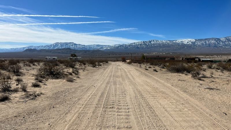
5 Acres in the Lucerne Valley area, zoned Residential, ELECTRIC
APN# 0449-531-46-0000
Payment Options
Payment Note(s)
If you are interested in reserving this parcel, click “Reserve Now” button for any of the payment options. You will be redirected to our payment page to make the initial reservation payment.
*Buyer to make their own independent investigations regarding zoning & General Plan Designations, Hazard Zones, Availability & Costs of utilities.
5 Acres FOR SALE By Owner in unincorporated San Bernardino County, in the Lucerne Valley area, zoned Residential, ELECTRIC close.
OWNER FINANCING Available with $0 upfront and $450 Doc Fee, $593 x 48 months
ATTRIBUTES:
* 5 Acres- lots of open space
* zoned LV/RL-5- residential rural living
* electric poles close- at the intersection of The End Rd and the Santa Fe fire road which is about 2000 west of the subject
* legal & physical access confirmed by the county & title company
PROPERTY DETAILS:
San Bernardino County, CA
APN: 0449-531-46-0000
Property Address: Second lot from E End Rd, located between Santa Fee Rd & Pot Belly Pl
LUCERNE VALLEY, CA 92356
TOWNSHIP: 04N
SECTION: 9
LAND USE: 400
ZONING: LV/RC-
Subdivision Information
SUBDIVISION PLAT BOOK: 0449
SUBDIVISION PLAT PAGE: 531
TAX AMOUNT: $268.32/ CURRENT
Lot/Land Information
ACRES: 5.00
LAND SQUARE FOOTAGE: 217,800.00
Legal Description
LEGAL: N 1/2 SE 1/4 SE 1/4 SW 1/4 SEC 9 TP 4N R 2E
POLYGON ((-116.78176295601 34.4448232554739, -116.781765851417 34.4439168139234, -116.779575221326 34.4438972454367, -116.779571452169 34.444805094784, -116.78176295601 34.4448232554739))
All information we have on this property is disclosed within the content of the listing page.
Any and all other information on this property should be directed toward the city or county of which the property is located in.
Your due diligence should be performed, to ensure the property meets your needs and criteria.
Directions
Please remember this a vacant land property, so there is no street address/ no street number. For directions simply use Coordinates or Google Map link:
34.4448232554739 -116.78176295601
Google Map:
https://goo.gl/maps/7wS9WJqAzZMPdFeM6
Drone Video:
All information we have on this property is disclosed within the content of the listing page.
Any and all other information on this property should be directed toward the city or county of which the property is located in.
Your due diligence should be performed, to ensure the property meets your needs and criteria.
About the Seller:
We are a husband and wife who love to invest in land.
We review thousands of properties for everyone that we buy in order to bring you the BEST deal possible.
The pricing we get them at is reflected in the pricing of what I am selling them for. They are priced at half the current market price or less TO SELL.
Because of their price they don’t usually stay for sale for very long.
The buyer is responsible for learning all the restrictions from the county/ township/ planning and zoning office.
What you can or cannot legally do on the land is controlled by the local government, not by us or any seller.
Please contact the county, providing them with the parcel number, to confirm zoning, access, and available utilities.
Thank you for searching and talking interest in our land!
Patrycja & Tom with Land Addiction
If you have any questions, TEXT Patricia: 773-398-8027
Property Information
Parcel Size
5
State
California
County
San Bernardino
Parcel Number
0449-531-46-0000
Address
LUCERNE VALLEY, CA 92356
Legal Description
N 1/2 SE 1/4 SE 1/4 SW 1/4 SEC 9 TP 4N R 2E
Features
Acres
5
County
San Bernardino
Subdivision
Exists
Access
Dirt
Coordinates
34.44448670723058, -116.78070911165443
Zoning

